Mapping and Geographic Information
What is mapping and how can it help achieve highly accurate data over large areas in a few hours?
The benefits of drone inspections are well established, helping you to cut operating costs and extend the service life of your asset, and include such examples as:
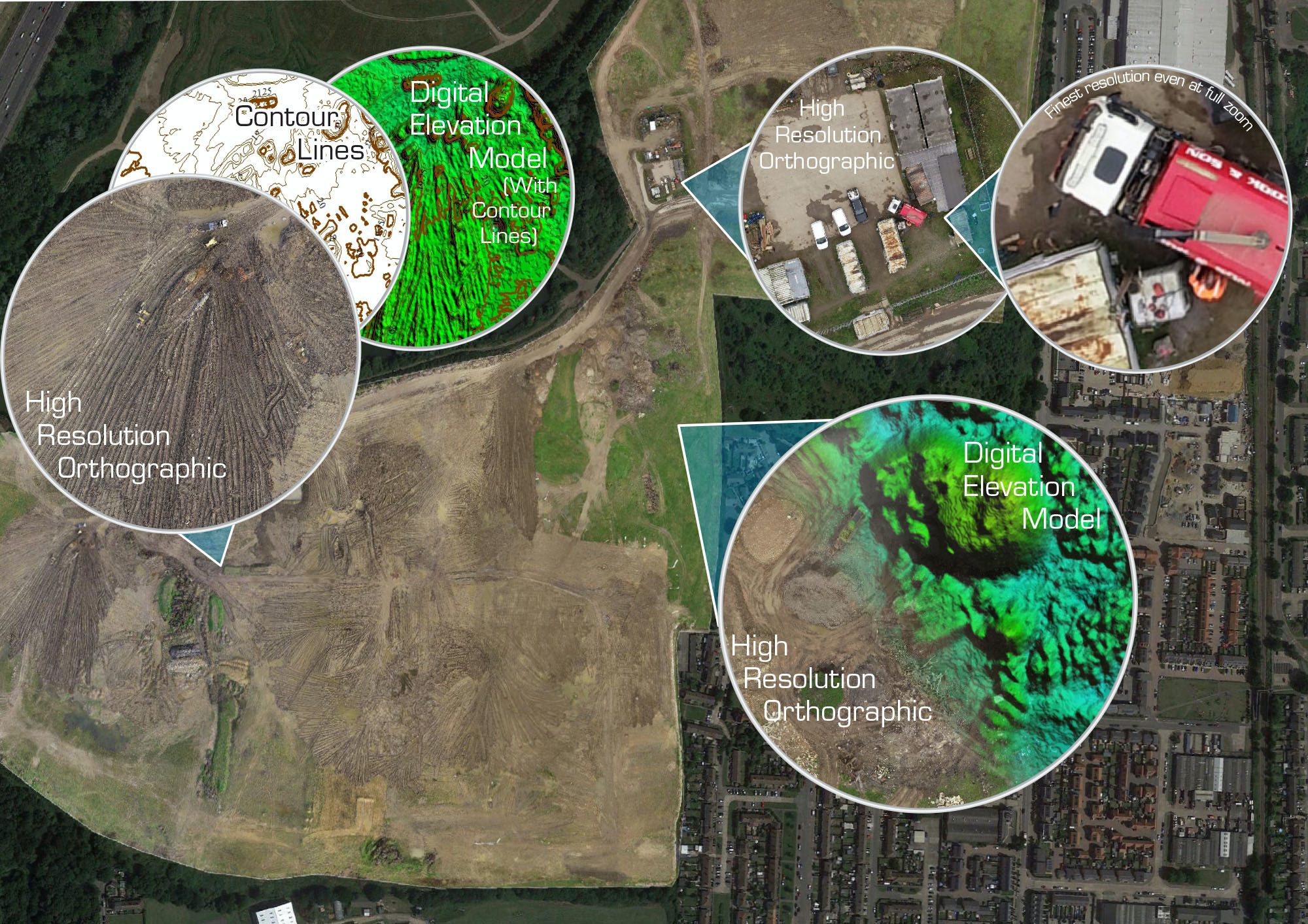
Using a drone to collect many overlapping images from height, creates a versatile and powerful dataset which can be processed into 2D and 3D information.
A combination of high-resolution cameras, specialist software and a proven level of proficiency in photogrammetry, enables us to deliver a vast array of map types and correlated services, very accurately – often within a few cm’s accuracy even over many km².
This means large areas are captured cost-efficiently and the data can be processed in a selection of uses and formats such as:
- Orthographic images for a high-resolution, birds eye view.
- Importing into 3rd party mapping software or CAD to be Interpolated into scaled drawings and point clouds.
- Annotating and labelling for an intuitive display of data.
- Digital Elevation Models (DEM) to provide a record of the elevation data.
And there is more…
Geographical Information Systems (GIS) allow us to do more with your data in the form of analysis, manipulation, and presentation. Examples include:
- Contouring, which is used to visualise topography in a 2D format.
- Volumetric and area calculations, such as large material piles or excavations.
- 3D visualisations, so you can clearly see you subject in 3D.
- ‘Flyovers’, or ‘tours’ which are ideal for showcasing and marketing.
Further productions can be achieved via similar surveying methods to include point clouds and 3D modelling.
CLICK HERE to book your free online consultation and demonstration during which we will explain in detail how a comprehensive drone survey will add significant value to your project.
CONTACT US NOW on email [email protected] or call 0333 990 9847
SERVICES WE OFFER
WIND TURBINE INSPECTIONS
SOLAR SERVICES
CLOSE INSPECTION & SURVEY
MAPPING AND GIS
INSPECTION PORTAL
3D MODELLING
GROUND CONTROL SOFTWARE
CONSULTANCY AND TRAINING
DETAILED THERMAL INSPECTION
“The service and data delivered to us by Futurewise Aerial was top class. The findings saved us loads of time and lost efficiency, thanks.”
Ryan McShea – Empower Energy Ltd